Utility Mapping
Our underground utility mapping service works to industry recognised Publicly Available Standard (PAS 128) and is often required to make effective plans based on features present on a development site and ensure the safety of workers and the public during excavation and construction work.
Full UK coverage
Big or small projects welcome
Highly experienced and friendly team
Fully insured
Get Your Free Quote
Everything you need to know about Utility Mapping
Over the course of a planning project involving land that has already been developed, multiple stakeholders in the process can benefit from understanding any and all components that may be hidden on the site. Without this level of insight and quality assurance, project planning could be significantly hindered by elements on the site that aren’t necessarily obvious, or potentially hazardous wires or pipes, for example, could cause harm to unsuspecting construction workers that unknowingly come into contact with them.
Sometimes referred to as a GPR survey, an underground utility survey, underground utility mapping, utility detection or simply as a utility survey, a utility mapping survey provides a thorough overview of components hidden beneath the surface of developed land. The results of mapping utilities in a subsurface environment can then simplify the process of preparing a plan for projects through detailing information on the present obstructions within the ground that could have otherwise gone undetected and potentially caused severe issues later in the process.
What is Utility Mapping?
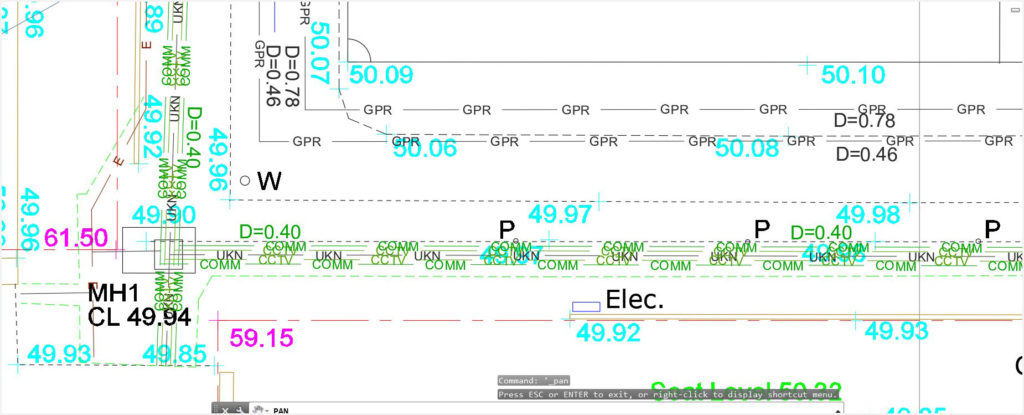
Utility mapping is an approach used to identify cables and pipes below ground. As well as the presence and location of these features, underground utility mapping will also help to determine the positioning and routes of piping and wiring. Using specialist equipment, land surveyors with proven experience can visit a plot land and utilise GPR surveys to find all elements that are hidden or obscured by the existing conditions of the area before adding them to an accurate map of the site.
Sharing similarities with a topographical survey, utility mapping also focuses primarily on gauging the layout of a development site in a way that is non-invasive and non-destructive, seeing a site left unchanged and entirely avoiding causing any form of damage such as unnecessary excavation works. However, instead of looking at the piece of land in general, underground utility surveys specialise in features within hidden sections that wouldn’t be easy to find without an advanced analysis. Through combining the results of utility mapping and a topographic survey, a developer can have a comprehensive map of their development site, playing a key role in eliminating potential obstacles to see continuing success in their project.

Objectives of Utility Mapping
In any underground utility mapping exercise, the primary objective is to retrieve reliable data from subsurface areas in a way that focuses on hidden or buried utilities such as fibre optics, gas pipes, power cables, sewerage pipes, telecommunication cables and water pipes. It is often treated as a precautionary measure that will find unexpected features early, reduce the potential harm to professionals on the site, remove the likelihood of hazards appearing in the near or distant future, and prevent costly or time-consuming delays in the planning process.
As such, the utility data collected from a utility mapping survey can be used to benefit a number of purposes. In the construction industry, for example, utility surveys are needed on developed ground to investigate underground utilities before any construction work can take place.
Importance of Utility Mapping
Alongside acting as a mandatory consideration in certain construction, development and excavation projects, below ground services such as underground utility mapping surveys carry numerous benefits. Due to this factor, the option to choose this type of assessment over other similar but distinctly different surveys may be crucially important for developers undertaking specific types of planning project.
Benefits of Utility Mapping
- Converts potential ‘unknowns’ into ‘knowns’, removing any speculation
- Eliminates the need for unnecessary digging, offering an excavation-free method
- Leads to as-built data in real time
- Minimises down time caused by unexpected issues and lengthy delays
- Reduces the overall cost of the project
- Supplements numerous considerations for the price of a one-off assessment
Utility Mapping Survey
When a utility survey has been arranged at a date and time that suits the client, a licensed surveyor will visit the site to conduct an assessment in line with the rules of PAS 128. Prior to this, however, they will conduct a desk study in order to retrieve data that could benefit the survey such as information regarding underground services present on the site.
The land surveyor will then attend the development site and search for the utilities identified during the desk study and determine if any other previously unidentified utilities are also present. With the help of electromagnetic location (EML) and Ground Penetrating Radar (GPR) techniques and devices, all metallic and non-metallic features buried in the ground will be located.
EML and GPR technology will then be used to find the positions and routes of each feature within the ground, and the details of the underground utilities will be recorded and added to an accurate drawing of the site. In some cases, if further information is needed, the land surveyor will take a more in-depth approach to determine culverts, obstructions, rebars, voids and any other underground features that may have been impossible to identify on the site during the visual inspection.
GPR Utility Mapping
A key component in utility surveys is the use of Ground Penetrating Radar (GPR) technology. GPR – abbreviated from Ground Penetrating Radar – is a technique that involves using electromagnetic energy to create an image of the area below the surface of the ground. GPR works as a geophysical locating method, using radio raves between the frequencies of 1 and 1000 megahertz (MHz) and the latest IDS stream to send echoes into the ground and locate where features are situated during a single scan.
Ground Penetrating Radar for Utility Mapping
Traditionally designed in the form of a large device that can be pushed using both hands in similar style to a lawnmower, a land surveyor would typically run the GPR over the specific plot of land. A transmitter would then send electromagnetic energy through the ground, into the soil and other features present such as cables and pipes.
Once the emitted electromagnetic pulse comes into contact with any objects in the ground, the signal is reflected, refracted and scattered, and the returning signals are recorded by a receiver attached to the GPR device. A screen at the top of the device will show the surveyor any findings from the survey, and built-in utility mapping software translates the signals into images of subsurface objects. Data from the assessment can then be drawn up into a map of both natural and man-made features on the site.
Utility Mapping Equipment
Although different types of equipment may be used based on the specific approach of the land surveyor, or other tools harnessing the latest technology that would be needed if the underground utility mapping exercise was combined with another assessment such as a topographical survey, the equipment needed for utility locating is often the same.
Instruments that are typically used for utility mapping services include:
- Computer Aided Design (CAD) software
- Electromagnetic Locators (ELM)
- Geographic Information Systems (GIS) software
- Global Positioning System (GPS) software
- Ground Penetrating Radar (GPR)
- Robotic Total Stations
Utility Mapping Standards
As a way of ensuring that all utility surveys consistently deliver the same insights and offer complete quality assurance, it is important that our land surveyors follow a universal methodology. Created in partnership between the Institute of Civil Engineers (ICE) and the British Standards Institution (BSI), the Publicly Available Standard 128 (PAS 128) was published under licence in June 2014.
While it is always our intention to follow the specifications of our clients and guarantee that their aims are met, all of our assessments that relate to underground utility mapping, detection, verification and location are carried out within the standard of PAS 128.
Survey Category Types
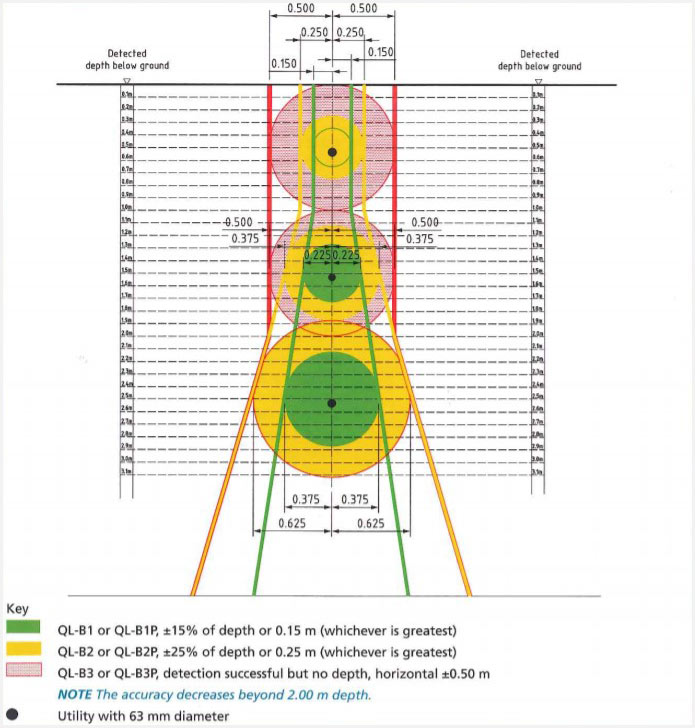
PAS 128 provides a methodology specifically for delivering underground mapping correctly. One of the important aspects of the set of rules is the level of accuracy, as outlined using several core survey category types. In total, there are four different category types ranging from D to A, with each covering a certain outcome from a utility survey:
PAS 128 Survey Category Type D
Utility surveys solely using utility record data during a desktop utility record search and no geophysical methods on the site.
PAS 128 Survey Category Type C
Utility surveys solely using utility record data during a desktop utility record search, but with site reconnaissance to ensure that the data matches up with physical utility street furniture.
PAS 128 Survey Category Type B
Utility surveys using geophysical methods to develop a linear five-metre section of utility depicted as a Quality Level (QP) 1-4 for horizontal / vertical position accuracy depiction on the site.
PAS 128 Survey Category Type A
Utility surveys using physical identification in the form of trail pitting, utility chamber inspection or vacuum excavation works to confirm the presence, location and positioning of utilities.

Utility Mapping Services
Following years of quality service, The Survey House has shown continuing success for utility survey solutions. Ranging from private and public endeavours, to construction work or projects that benefit facilities management sectors, for example, we are ready and able to assist you with underground utility mapping survey services on your site, all with the utmost quality assurance.
Our land consultancy services are effective and impactful in underground utility locating on any site and creating an accurate map in a way that is non-destructive, non-invasive and avoids unnecessary excavation works. Based on the nature of the site and the findings from the preliminary desk study, we can provide suitable survey solutions for you.
Whether it involves a simple retrieval of data in regards to subsurface fibre optics and wiring, or a far more advanced approach that requires non-destructive digging to gain assurances over positioning of a multitude of underground services and utilities present, we consistently deliver a quality service to countless private and professional clients in a wide range of industries.
Utility Mapping Surveyor
With proven experience and qualifications in relevant areas, our land surveyors are capable of survey services on your site that will outline all buried services and underground utilities present. As well as quality assurance through insightful and knowledgeable mapping services and safe working patterns to avoid causing serious injury, our company structure makes it possible for land surveyors to be based all over the UK, covering numerous areas and meeting the needs of all clients without any restrictions based on location.
A key part of facilities management sectors, underground utility mapping services can apply to an array of industries. To meet the demands of different clients and consistently deliver a high standard survey, our licensed surveyors hold proven experience and knowledge on utility locating and producing the best results regardless of the development site and the purpose of the assessment. Our land surveyors consistently deliver a similarly high quality service to clients, and following utility surveys, they will produce a comprehensive map of the site under best practice guidelines as well as a report that includes details of the assessment and any key findings that need to be highlighted.
Utility Mapping Cost
A planning project is likely to incorporate several layers, and with that comes more costly factors to work into your budget. For safety and quality assurance, it is crucial that any required survey services are arranged early to book a suitable date and time for it to be undertaken and ensure that it is considered as part of the planning process.
Underground utility mapping is often a part of excavation projects and projects on land that was previously developed and therefore could house hidden underground utilities such as pipes and wiring. At a first glance, you may be concerned that survey services will add unnecessary costs to your project, but as it could prevent any number of costly implications further down the line, reduce the number of unexpected delays, and eliminate harm coming to construction staff and anyone else on or near to your site in the future, paying for survey solutions is a worthwhile investment.
How Much Does a Utility Mapping Survey Cost?
Every quote for utility surveys is bespoke to the needs of our clients, making it possible for it to be cheaper on a smaller, simpler site as opposed to a larger, more complicated site. However, the cost of an underground utility mapping survey is primarily charged on a day rate basis that reflects the level of input needed, including whether one land surveyor can conduct the survey or if multiple members of staff are needed. The office time required to produce the completed map and report are also included in the day rate that we use to generate a tailored quote.
On average, it would be likely for our clients to expect a fee somewhere between £600 and £1,500 per day. It would be advisable, however, for anyone interested in booking a survey or simply enquiring to get in touch and speak to us directly so we can give you an accurate quote. You can then decide if you would look to proceed with The Survey House, with no obligation to continue.
Booking a Utility Mapping Survey
For a tailored quote based on the specifications of your site and project, get in touch with The Survey House. We can then assess your site and the reasons behind why you are requesting our survey services to determine the best course of action between a basic desk study or a non-destructive digging on the site that will directly confirm or deny the presence of each underground utility.
Simply contact us by filling out our quick quote form or by calling us directly using the number above, and one of our team will be able to take down your information before providing you with a free quote. If you are happy with the quote we give you, we will work with you to book in a desirable date and time to visit your site for an underground utility mapping survey. Then, within a few days of completing the survey, you will receive your completed map and report, and with the insight inside, you can follow us in taking the correct next steps to find continuing success with your project.
Utility Mapping Done
in 3 Simple Steps
We know that you want your Utility Mapping done quickly and efficiently to avoid delays and to help your project run smoothly. Our simple process makes everything hassle free and straight forward.
Give us a call or fill in our quick onlne quote form to tell us about the project you need a survey for.
We will put a quote together based on the information you give us and we’ll get in touch via phone or email if we need any more information.
You'll get your free, no-obligation quote via email. If you are happy with the quote, simply let us know and we will book in a conveinient date to do your survey. Finally, we’ll send your report a few days after the survey.
